The findings of field studies conducted in 2021 by the Cowichan Valley Regional District that examined natural hazards in the coastal zone, causes of slope instability and potential impacts of sea level rise were revealed to Saltair residents during a public information meeting.
Dr. Richard Guthrie and Hawley Beaugrand of Stantec Consulting made two presentations at the Saltair Community Centre last Thursday, June 2 that followed an electronic information session May 16.
The purpose of the open house was to provide further opportunity to present and discuss the Saltair Coastal Slope Stability Assessment and draft Bylaw No. 4427 Development Permit Area 7: Landslide Hazard (DPA 7). The draft bylaw guides development activities in areas that may be subject to natural hazards and has been amended to include the report recommendations and new mapping.
The initial hazard assessment focused on the steep coastal and ravine bluffs within Saltair, but also identified additional risks inland in the course of that work, that have resulted in expansion of the existing development permit area to protect the community from risk.
“This study identified the potential for retrogressive landslides to occur affecting properties along the coast and adjacent to the Stocking Creek and Porter Creek ravines,” noted Lynne Smith, CVRD Area G Saltair/Gulf Islands director. “This information will be used to update the Official Community Plan to ensure development near steep slopes is done in a way which mitigates any risks to life or property.”
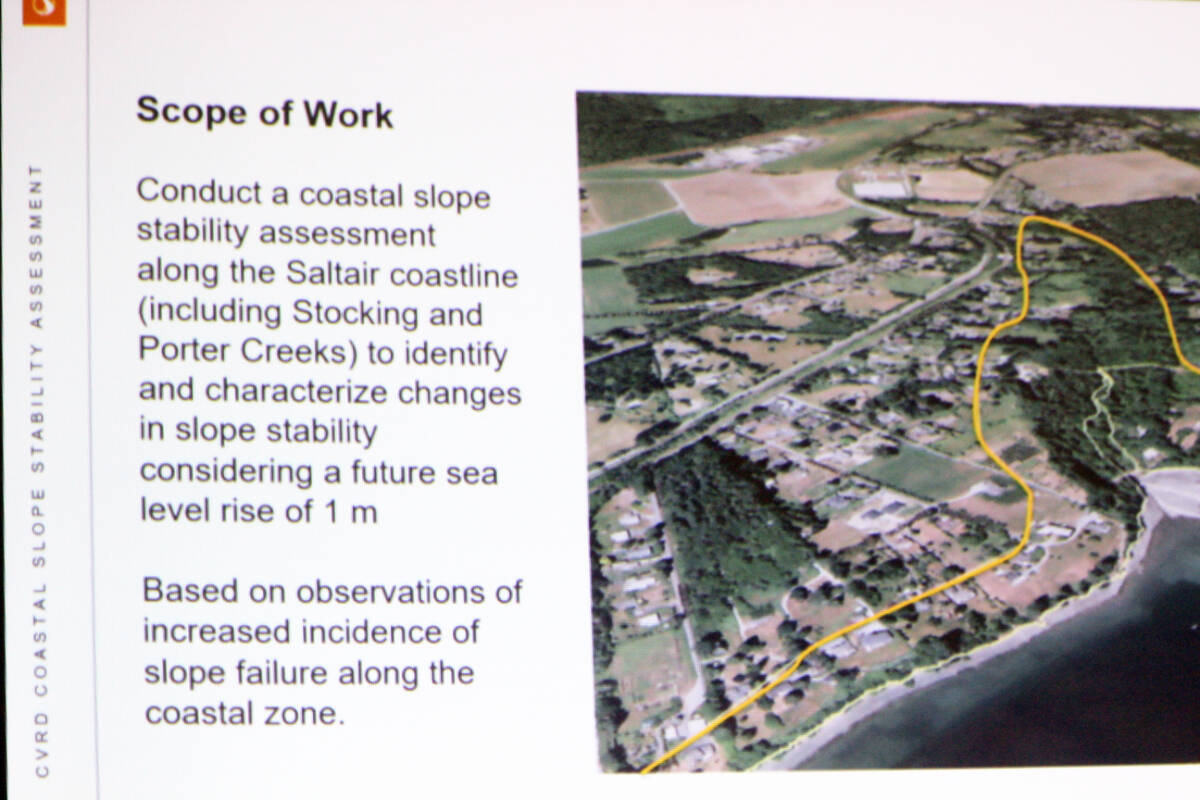
The scope of the work was to identify and characterize changes in slope stability considering a future sea level rise of one metre and based on observations of increased incidents of slope failure along the coastal zone.
Beaugrand referenced the background where ” we generally saw shallow failures along the bluff,” she said.
The researchers needed to assess the complicated geology relating to numerous factors and also were guided by geotechnical reports.
“We know there’s clay present, and the existence of low-angle landslides suggest that it extends really far back into the community,” noted Dr. Guthrie.
“There’s clear evidence that suggests slopes aren’t entirely stable in there.”
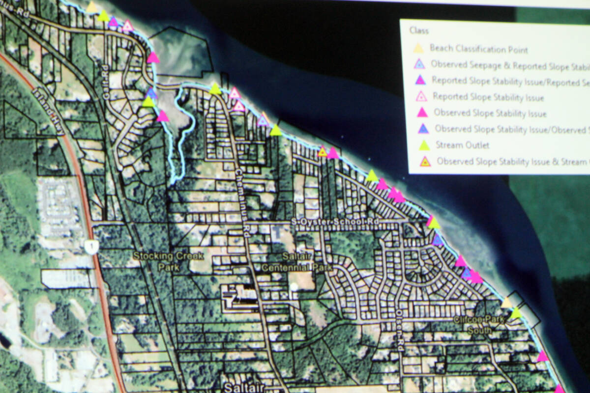
Field observations included: high clay content and clay seams along portions of the bluff with the greatest relief; common relatively shallow failures; failures related to uncontrolled discharge of storm water; and natural shoreline segments remaining undercut.
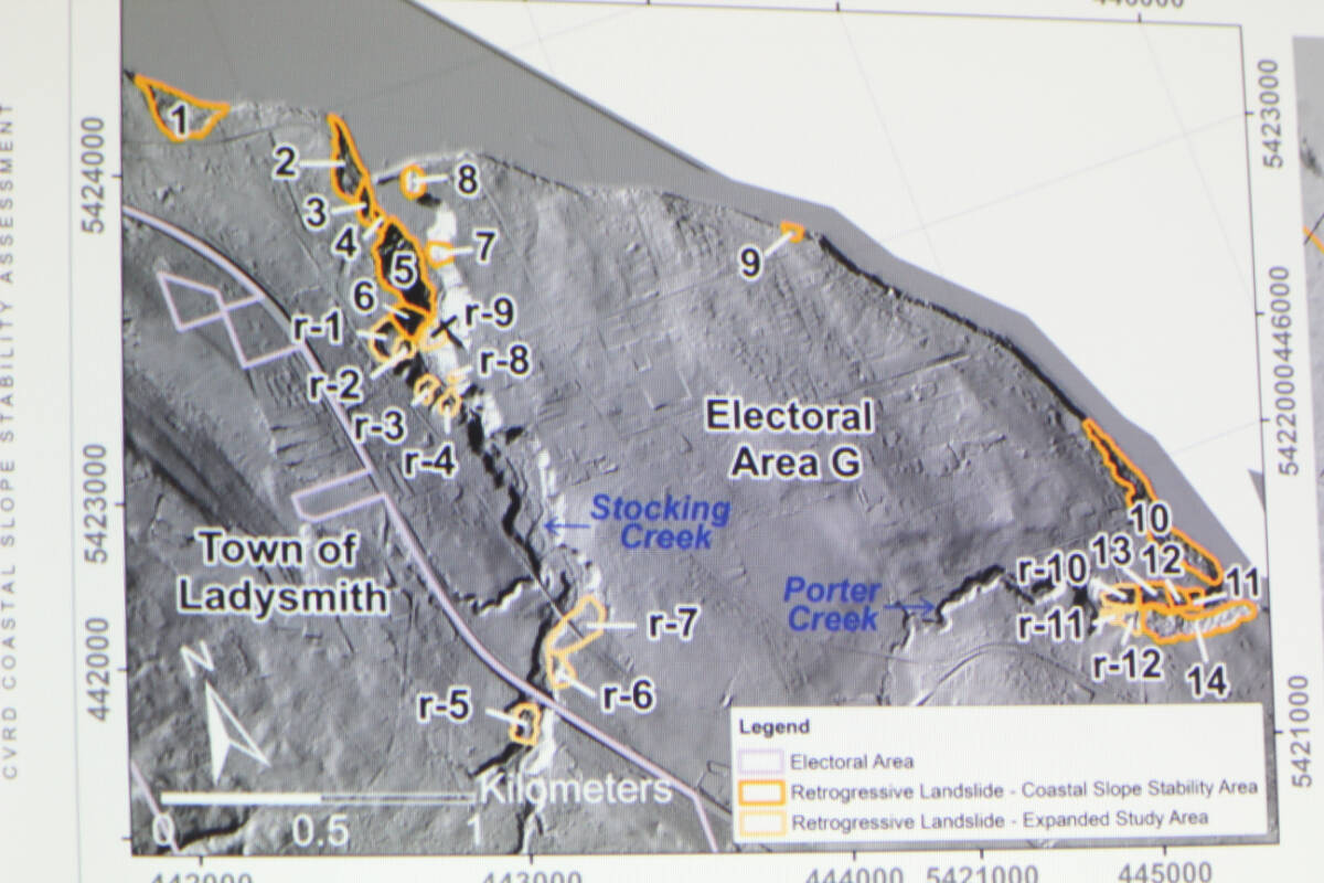
Landslide activity in the past was identified in the Stocking Creek and Porter Creek areas.
“We have about 14 of them in our initial mapping,” said Guthrie. “Some of them are really quite large. It has the potential to impact people who live in those communities.”
“The 14 are landslides that have already occurred,” clarified Kate Miller, the CVRD’s manager of environmental services. “These newly ‘discovered’ slides provide rationale – and critical technical information – for the development and expansion of the DP area back from the coast line, where additional slides may occur similar to the magnitude of the ones that have failed already.”
“The analysis was based on LIDAR imagery,” added Jeff Moore, senior environmental analyst for the CVRD. “This technology uses laser pulses from an aircraft to essentially see through the vegetation to create a very detailed image of the ground surface. The LIDAR revealed the presence of 14 large landslides which are estimated to have occurred over the past 500 years, with the most recent one believed to have occurred within the last 10 years. The same ‘flat over steep’ terrain is found along much of the coastal and ravine bluffs in Saltair, so geoscientists have identified a risk of similar landslides occurring in the future.”
Determining the probability of occurrences becomes complex, utilizing mathematical formulas. The risk level is low in any given year, but becomes more significant when considering longer time periods such as the 50-100 year lifespan of a house.
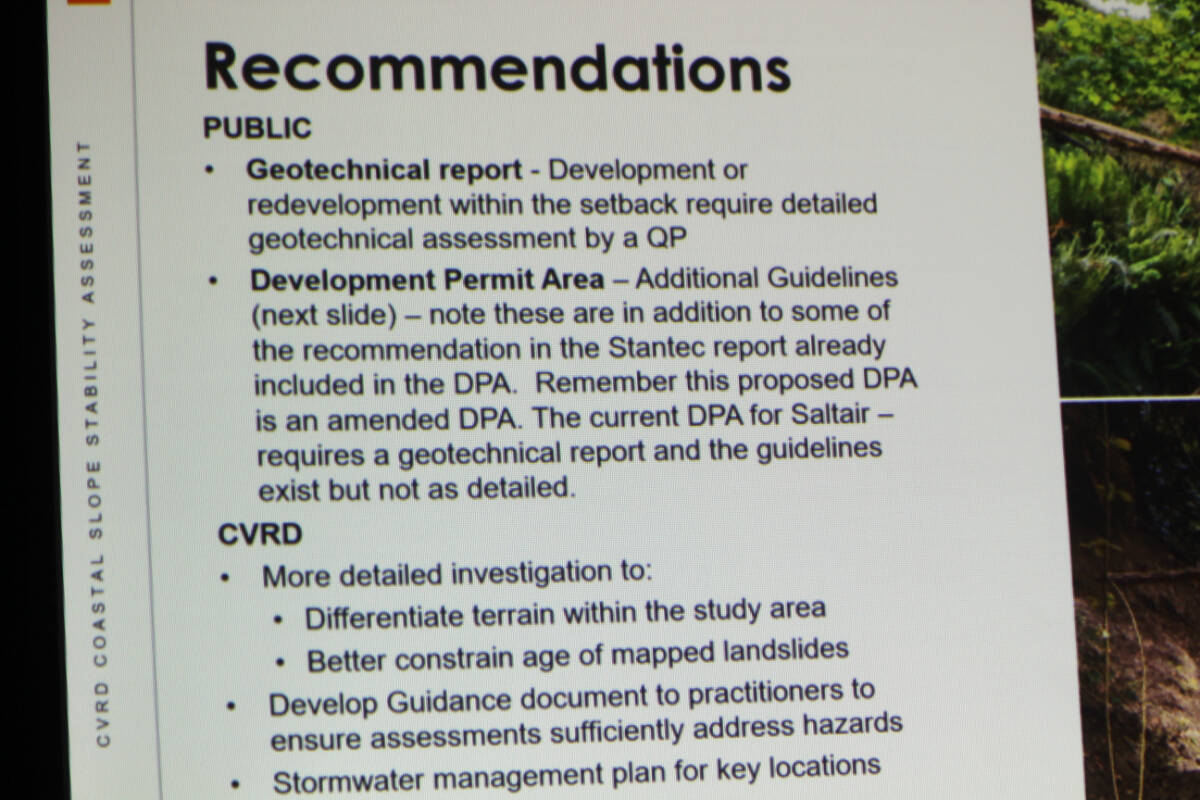
Recommendations from the study were made to both the public and the CVRD about how to proceed with the available data.
The full report is available here.
The draft Bylaw 4427 is available here.
Bylaw 4427 amends an existing DPA.