When it comes to Ladysmith’s trail system at the south end of town, what the Town’s maps say and what Google Earth and GPS say are not the same thing.
And that worries Ladysmith resident Brian Thom, a parent of young children and a professor at the University of Victoria who recently opened a mapping laboratory.
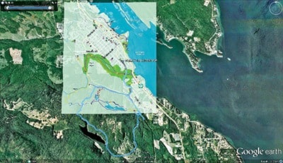
Thom addressed Ladysmith council June 18 to raise concerns about the Town of Ladysmith’s maps for the south-end trail system from Battie Road to Heart Lake. Thom shared overlays of data he collected using GPS and Google Earth and current Ladysmith Parks, Recreation and Culture maps to illustrate differences and inaccuracies.
Thom had taken GPS units out on a hike to Stocking Lake and was surprised by what he found. Current maps put out by Ladysmith Parks, Recreation and Culture are distorted and out of scale for the south-end system, making it difficult to locate the trails and hard to judge the length of outings, he explained to council.
“I took my family to the hike on the south end that goes up to the Stocking Lake trail, and what I want to present to you is that what I found is the map the Town has and on the brochures and signs on the trailheads is quite different than what is in reality on the ground,” said Thom. “On the map that Ladysmith has on their signs and on the trails, it appears much, much shorter than it actually is, and so, when judging how long it’s going to take for the hike and even where to arrive at the trailhead, we found it difficult.”
Thom and his family thought they were heading out for a two- to three-hour hike, but it took them the whole afternoon and into the evening.
“I think this is a safety concern, and I wanted to bring it to your attention,” he told council.
Since encountering the problem while hiking with his family, Thom has spoken to six other families who had the same problem and thought it looked like a reasonably short walk around Stocking Creek, but it actually turned out to be a much longer adventure.
Thom recommended that council direct staff to either re-make existing maps that are on all the signs, brochures and town website or provide some kind of inset or overlay that can better reveal the true geography of the south-end trail system.
Thom found that the town maps have rotated and shrunk the distances at the south of the trail system.
“They seem to line up on the other side of the power line but get distorted south of the power line,” he said. “I think the safety concern here and certainly just the enjoyment factor was when we were judging how far this was going to be, we really didn’t anticipate it to be this long. The same thing happened to the families I spoke to; all of us have kids, and all of us were out for a much longer hike than we thought.
“The other small problem is that there’s no signage or markers for the trailhead that are very clear to get up in this part, and I think this is a well-known problem.”
Ladysmith Chamber of Commerce president Rob Waters told council staff at the Visitor Centre are receiving similar criticism and hearing that it is hard to find the trails and to figure out when to make appropriate turns once they’re on the trail.