“It’s visually stunning.”
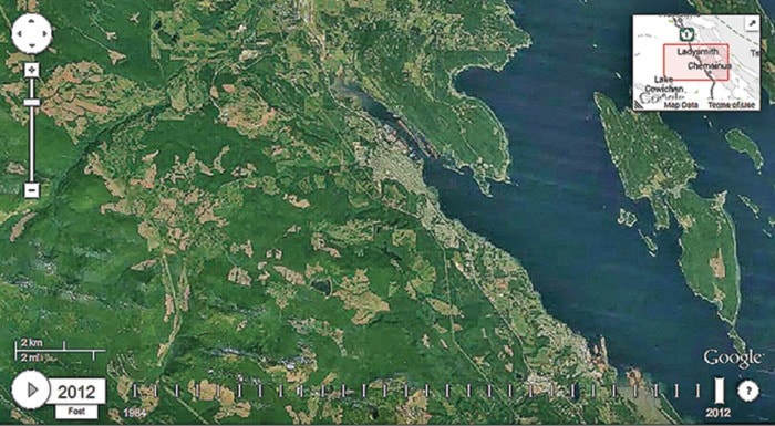
That was the impact experienced by Dr. Brian Thom after viewing a short video he created that tracked nearly three decades of land use in and around Ladysmith.
“It really shows what we can often see glimpses of: the extensiveness of deforestation in the watersheds behind our town, and the pace or development in areas like the south end.”
The video, which uses satellite images, shows the vast amounts of deforestation and development from 1984 to 2012.
“I just don’t know if this is the picture of land use the public has in their mind’s eye when they think about the east coast of Vancouver Island.”
Thom, a Ladysmith resident who teaches at the University of Victoria, attended Google’s Geo for Good 2013 User Summit late last year.
“It was showing us deforestation in Brazil and urban development in Dubai and I thought, ‘OK, what does Ladysmith look like,’” the professor of anthropology recalled.
Thom said the local image was as striking as anything viewed at the summit.
“I thought this was an incredible story about the change in our landscape over time.”
Thom spent about 10 years as a negotiator with the Hul’qumi’num Treaty Group and said the group had presented at the Inter-American Commission on Human Rights — one of the bodies that comprise the inter-American system for the promotion and protection of human rights — a number of times about the impact of forestry on private land on the First Nations ability to practice their culture.
“I was sitting here and I made this map in about 15 minutes using this Google on the Earth Engine and it tells the story completely — it’s far more compelling.”
Thom said the map he created will give Ladysmith residents the ability to see for themselves, in dramatic fashion, the amount of land usage and will give them vital information when it comes to making future decisions.
“Right now, we think about the debates around whether Ladysmith should include [Couverdon Real Estate’s boundary extension proposal to extend Ladysmith’s boundaries to include about 700 acres of TimberWest land northwest of town] and the tradeoffs to benefit the water supply,” he said.
Thom said it was the amount of private land deforestation that first grabbed his attention.
“It just jumps out so vividly on a map like this where you can see, really, that private land logging is much more active that Crown land logging,” he said.
“If you look at the map and Holland Lake and Stocking Lake — where we get our drinking water — you can see exactly where the forestry comes right around the lake.”
But the professor isn’t against logging.
“There’s a lot of land use decisions people should be informed about.”
To view Thom’s map, click here.